|
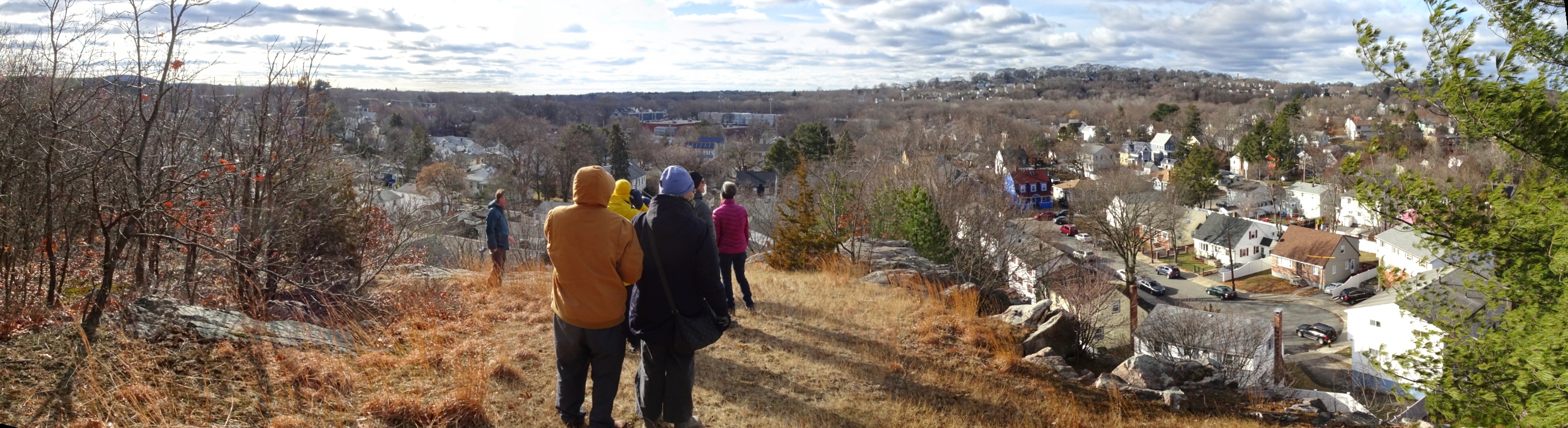
Crane Ledge is a rock cliff looking southwestward across Hyde Park and the
valley of the now-buried Stony Brook. The stone ledge is mostly open,
but it is backed by a significant forest of mature trees which preserve
a sense of wilderness for the entire site and keep the area cool on hot
days. The view across the valley feels rural despite the fact that it
overlooks a dense urban neighborhood, and gives a rare sense of Hyde
Park of more than a century ago when Crane Ledge was a site for weekend
picnics. It is now mostly overgrown with low brush, but could host a
network of trails which would provide access to the woods and views. It is
publicly accessible from American Legion Highway (/Parkway) in Roslindale
to the west and Ruskin Road to the south. An additional path from city-owned
land at the base of the cliff might be possible. Access from the Walgreens
end of the shopping mall, the back of Oak Lawn Cemetery, and Victoria Heights
Road is also possible.
|
| Upcoming Events
[Past Events] |
|
|
| Photos |
Neighborhood Crane Ledge Tour, January 31, 2021
[Google Album]
3rd Annual First Day Hike to Crane Ledge, January 1, 2021
[Google Album]
Aftermath of Construction on Crane Ledge, October 25, 2020
Construction on Crane Ledge, September 28, 2020
[Google Album]
Crossing Stony Brook Valley with Charlotte, May 30, 2020
Quarantine Walk to Crane Ledge, May 16, 2020
Stony Brook Valley from Crane Ledge, March 7, 2020
2nd Annual First Day Hike to Crane Ledge, January 1, 2020
Thanksgiving Walk to Crane Ledge, November 21, 2019
1st Annual First Day Hike to Crane Ledge, January 1, 2019
|
| Maps |
Historical Maps and Images
Crane Ledge Forest Threatened
Google Aerial Photo
Google terrain map
|
| Resources |
Proposed Development 2021
Potential Land Parcels for Crane Ledge Urban Wild
"Sally Rock Quarry" 1979 Geology by James W. Skehan, S.J. from "Puddingston, Drumlins, and Ancient Volcanoes"
"Sally Rock Quarry" 1981 Archaeology by William F. Bowman in the "Bulletin of the Mass. Archaeological Society"
1970 Boston Redevelopment Authority Study of "Barry's Quarry"
of which this is part
The Lost Road and the Towers of Doom
by Adam Gaffin
in the Universal Hub, November 18, 2012
|
|