| Touring
routes report home page Table of Contents Previous: Connecticut to Lenox Next: Lenox to Vermont Border |
|
| Touring
routes report home page Table of Contents Previous: Connecticut to Lenox Next: Lenox to Vermont Border |
|
South Berkshire Side Trips
Cue sheet northbound | Cue sheet southbound
The side trips from the Berkshire County main route are intended to offer variety and alternatives, and to lengthen the tour for a through-traveling bicyclist who has extra time to spend. The side trips are especially useful to vary the route for a rider who is making a round trip. They also may be combined with sections of the main route to form shorter loop routes for local rides. Most of the side trips are best traveled in the direction which corresponds to south-to-north travel along the main route. Exceptions will be noted.
The side trips are described here in order from south to north:
Side Trip 1: Umpachene Falls, Mill River
This 10-mile side trip provides a taste of the Berkshire foothill country east of the main route. The highlight of the trip is scenic Umpachene Falls. The general store in Mill River serves as a refreshment stop. Unlike the main route south of Great Barrington, this side trip includes some climbing; but the grades and total elevation gain are moderate.
Traffic on this route is light to moderate, and heaviest on County Road, which serves as a link between valley and hill communities to the east. County Road probably ought to be widened in a decade or two if the attractiveness of this route is to be preserved. One alternative is to suggest that riders take this trip counterclockwise, because the downhill trend of County Road will let them keep up with the traffic for the most part.
Side Trip 2: Mount Washington, Bash Bish Falls
This side trip, 24 miles long, is a real climbing challenge, through the scenic Mount Washington State Forest. Some bicycle tourists seek out this type of workout for its own sake, but this route offers another reward as well: a visit to 200 foot high Bash Bish Falls, the most spectacular in western Massachusetts. The route returns vis the public swimming area at Ore Pit Pond and the town of Copake, New York, where there is a store that can sell mid-trip refreshments.
It is unlikely that much traffic will use the back roads on this route for the foreseeable future. Most motorists going to Ore Pit Pond or Bash Bish Falls (and there are few: Berkshire bicycle author Steve Lyons suggests Bash Bish falls as a secluded swimming hole) enter from the west via Route 22 in New York State. Route 23, on the other hand, does carry considerable traffic, and might need some widening in the foreseeable future in order to remain attractive for bicycling.
Warning signs are appropriate for the descent on the steep, winding section near above Bash Bish Falls. See the comments on the Mount Greylock side trip, below, for a longer discussion of this issue.
Side Trip 3: Great Barrington
This side trip of less than 3 miles offers a refreshment stop and views of the Victorian mansions of Great Barrington at the expense of a significant climb for northbound riders. The climb is past the mansions, so riders may wish to walk this section. When traveling southbound, the climb out of Great Barrington is in open country and is less difficult, extending over a much greater distance. Side Trip 4, Monument Valley, branches from this side trip, and either end of Side Trip 3 may be used to complete Side Trip 4.
Alternate routes through the town center of Great Barrington might be possible; there are two bridges across the Housatonic River in addition to the Route 7 bridge. Also, it is possible to avoid some of the the steep climbing by remaining on the hill in the mansion district; but this alternative foregoes a trip into the shopping district.
Side Trip 4: Monument Valley
Beginning at the midpoint of side trip 3 in Great Barrington, the 11-mile side trip to Monument Valley offers some of the most attractive scenery in the Berkshires. Also, it serves as a major alternate route and shortcut between Great Barrington and Stockbridge. Mostly, grades are moderate, but there is a short, steep climb on Route 23 to Monument Valley Road when traveling north. For this reason, unlike most of the other side trips, this one is more attractive when traveling south. It can serve as an alternate return route and shortcut for tourists who have traveled north along the main route.
The passage through the center of Great Barrington might be improved by the same measures suggested for Side Trip 4. This trip might also be modified, or an alternate provided, as an extension of Side trip 1, providing access to the campground in Beartown State Forest via Buel Road.
Side Trip 5: Stockbridge Sights
Stockbridge offers a very high concentration of points of interest, and so this 6-mile side trip takes in several Stockbridge sights not accommodated on the main route:
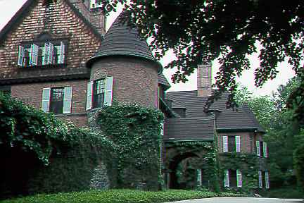
the Victorian Naumkeag mansion, open to the public along with its extensive formal gardens, and the Daniel Chester French studio, as well as Alice's Restaurant and other sites immortalized in the Arlo Guthrie song. The route crosses Route 102, which may be used to complete a loop for tourists staying in Stockbridge. This loop is suitable for bicyclists of moderate abilities, except that it does include a fair amount of climbing. There are fewer steep climbs when traveling from west to east, the preferred direction.
There are many alternative routes possible for sightseeing in Stockbridge. Some are easier to ride; though none on roads which go outside the town center can be suitable for outright novices, as the center is surrounded by hills and valleys. Since this limitation is a given condition, the side trip here also includes dirt roads and roads with more traffic than novices prefer. However, a shorter, novice-oriented route might be provided as well. Note that Church Street (Route 102 north from the Town Hall) is narrower than other parts of Route 102. It is partly for this reason that the through touring route avoids it. Ideally for bicycling, it should be widened by about four feet. Note that there is much open land around Stockbridge where trails might be developed; and considering the wealth of attractions, this approach would certainly attract riders.
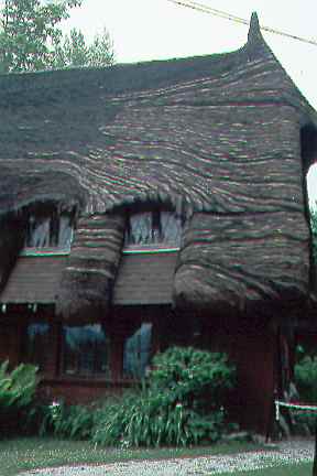
Side Trip 6: Gingerbread House
This short detour on the route between Stockbridge and Lee has one major destination: the very unusual Henry Hudson Kitson Gingerbread House art gallery in Tyringham. There is a witch's face formed by windows and thatch on one side of the house.
Riders who wish may continue to the Tyringham town center and then climb the steep hill to Monterey, which has a general store and roadside restaurant. On the return route into Lee is a spring dispensing cold, fresh water, welcome on warm days when bicyclists empty their water bottles quickly. Along with the corresponding part of the main route and a spur into Lee, this side trip forms a short, relatively easy loop suitable for weaker or inexperienced riders.
There is no significant problem, actual or potential, with this route, except in the remote future when traffic might become heavy on Tyringham Road. Note that this route provides access to Beartown State Forest, but from the end opposite the campground and with a steep climb. The Beartown Mountain road might be a good choice for south-to-north travel by riders who have visited the campground.
Side Trip 7: Housatonic River, October Mountain
This 6-mile alternate route between Lee and Lenox follows a scenic section of the Housatonic River, then passes October Mountain State Forest, with its campground and trail system. Though this route is longer than the main route, there is less climbing. The loop route composed of this side trip and return on the main route is of moderate length and difficulty, suitable for riders of moderate experience.
The route through Lee might possibly be changed to avoid Route 20, which it follows for a short stretch; however, Route 20 provides access to the central business district, lodging and restaurants. In any case, traffic is slow here in the center of Lee.
Housatonic Street and Crystal Street in Lenox are not wide; however, traffic on them are light at present; they serve few destinations to which there are not more direct routes. It might be most appropriate to designate them as a bicycle priority route and apply a traffic-calming or discouraging strategy such as car barriers to turn parts of these roads into cul-de-sacs, rather than to widen them. In this way, Lenox could develop a high-quality bicycle through route extending from October Mountain State Forest to Tanglewood at an extremely low cost.
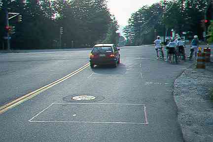
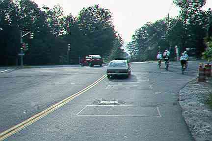
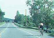
The traffic signal where Housatonic Street crosses Route 7 has a vehicle presence detectors which do not respond to bicycles.
The detector loops are wires buried in the pavement under the square cuts visible in the photo. The group of bicyclists rode over the loops, but the traffic light did not trip until the car drove up.
The car (the one now partway through the intersection) tripped the signal, the bicyclists could now proceed. If no car had shown up, the bicyclists would have either waited all day or had to cross against the traffic signal.
The sensitivity of the loops needs to be increased, and they should preferably be replaced with quadrupole loops (a better design which lets loops be more sensitive while avoiding false tripping by vehicles in the next lane).
| Touring routes report home page Table of Contents Previous: Connecticut to Lenox Next: Lenox to Vermont Border |
Prepared by John S. Allen, 1993 |
 Touring