| Touring
routes report home page Table of Contents Previous: Other Connecticut Valley routes Next: Bibliography |
|
| Touring
routes report home page Table of Contents Previous: Other Connecticut Valley routes Next: Bibliography |
|
BERKSHIRE VALLEY-CONNECTICUT VALLEY LINKS
The Berkshire and Connecticut Valleys are approximately thirty miles apart. The area between them is mountainous, with relatively few roads, most hilly and many unpaved. This environment attracts some bicyclists for off-road riding and a few for on-road challenges. However, most touring bicyclists will seek out the flattest routes through such an area. Two good possibilities for links between the valleys exist, each with variations and each with one or more problems.
Route 9 - Windsor Jambs - Route 116
This route follows River Road from the Leeds section of Northampton to Williamsburg, and Route 9 as far as the Cummington town line.
Massachusetts Route 9 is a major east-west highway through the Berkshires, between Northampton and Pittsfield. The fairly high volume of traffic, including heavy truck traffic, actually works to bicyclists' advantage, since it has led to the design of the highway to a very high standard. Grades are moderate and the wide shoulders can easily accommodate bicycle traffic regardless of the volume of motor traffic. On this highway, the motor traffic is more a cause of unpleasantness for bicyclists -- noise and exhaust odors -- than of conflict, delays and danger. In any case, traffic volume changes markedly from hour to hour and day to day, and an early morning crossing, for example, can find Route 9 almost empty.
West of Windsor, Route 9 westbound rises away from the Westfield River before descending into Pittsfield. There is additional elevation gain and there are also climbing lanes which take the place of the shoulders. The entry into Pittsfield is through an industrial and shopping area with unpleasant bicycling conditions. However, an alternate route along River Road through Windsor passes the Windsor Jambs State Park with its picnicking, camping and swimming facilities and continuing on Route 116, which is wide and carries very little traffic west to its terminus in Adams.
The last mile in Adams is very steep, and eastbound bicyclists, especially, may prefer the gentler grades of Wells Road from Cheshire, or East Street from Adams and North Adams. These roads make connections to Route 116 near the top of the climb out of Adams.
There is one remaining significant problem with this cross-Berkshire route: four miles of Route 9 between Williamsburg and Goshen which lack the wide shoulders.
Widening of the four miles of Route 9 between Williamsburg and Goshen should be a high priority, not only for the benefit of bicycle tourists but for other travelers as well. Given this improvement, the through route deserves to be designated and maintained as a preferred route for through bicycle travel.
Route 20 between Westfield and Lee essentially parallels the Massachusetts Turnpike. For this reason, Route 20 carries little traffic; adult bicyclists' main concern will be the climbing. This situation can be expected to continue for several decades, until major development for tourism occurs in the high Berkshires.
In the "Jacob's Ladder" section between Chester and Becket, the elevation gain is in a series of "steps," making the climb a greater challenge than on Route 9. The climb from Lee to Route 8 also is steep. Still, Route 20 does not waste the effort of climbing with repeated uphill and downhill sections.
An alternative to the Becket-Lee section is to travel northwest using Pittsfield Road through Washington, to William Street in Pittsfield.
The Pioneer Valley Planning Commission is looking into potential improvements in the Route 20 corridor. An abandoned railroad grade parallel to Route 20 could provide a less challenging climb for at least part of the route, and an alternate if traffic increases to the degree that it degrades bicycling conditions. (Unfortunately, the western portion of this railroad alignment was taken over by the Massachusetts Turnpike for the descent into Lee.) Though the remainder of the railroad grade represents a resource that should not be lost, the potential ridership for this route is questionable for the near future.
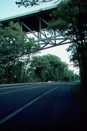
Most of Route 20 has wide shoulders, and traffic is relatively light because the Massachusetts Turnpike carries through traffic. The photo shows Route 20 under the Turnpike overpass in Russel..
The potential of Route 20 and the Route 20 corridor should be maintained and improved for bicycling in the course of normal road maintenance and upgrading. Particularly, the section from Lee to the junction with Route 8 in Becket should be upgraded to a minimum width of 28 feet, as there is no good alternative for a southern route across the Berkshires. Problems in the eastern part of the corridor are less pressing, due to the light traffic. The railroad grade could be acquired as a resource and perhaps developed as a mountain bike and snowmobile trail, requiring no expensive improvements. If demand is demonstrated, then improvements could be undertaken.
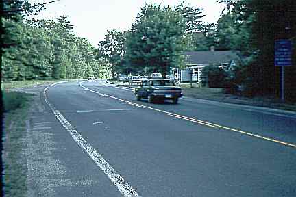
There is a short section in Westfield, as well, which could be widened. The photo shows the shoulders disappearing at the town line between Russell and Westfield.
Route 2, the northernmost route, carries heavy traffic and has sections which are only the minimum 24 feet wide, including the challenging climb over Whitcomb Summit. Though some bicyclists like the climbing challenge, Route 2 can not serve as an attractive through bicycle route unless improved significantly. However, sections between Zoar and Charlemont and from Route 112 to Shelburne Falls are wider, and form important links in routes popular with local bicycle clubs.
A number of minor highways cross the Berkshires -- Routes 57, 23, 143, 116. All of these are at least in part narrow and winding, and waste elevation gain with repeated ups and downs. These highways are a greater challenge and, under any but very light traffic conditions, present greater risks than the more wide-open highways.
It is possible to build up complicated routes which cross the Berkshires on lightly-traveled roads, but these are invariably long and usually very hilly. They are better thought of as mountain challenges than as through touring routes. An example of this type of route is the century (100 mile) route included as an appendix to this report.
| Touring routes report home page Table of Contents Previous: Other Connecticut Valley routes Next: Bibliography |
Prepared by John S. Allen, 1993 |
 Touring